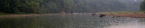
- A shallow water vista

My photos from this trip are here.
This part of Tennessee has had no appreciable rain this month. The grass in my yard has been crunching when I walk on it. Yesterday evening, after a quick supper, I mowed the front yard. I really shouldn’t have, but the grass was growing too high in places. Then I loaded the car with gear still ready from last weekend’s aborted mission, and put Campsis Radicans on the 850’s racks.
I left the house not as early as I wanted, but by about 6:20 am. I got stuck behind a cement mixer at a four way stop near Toliver Lake, but managed to get on the water by about 7:00 am.
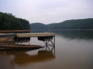
- Fire Lake Boat Ramp, a little before 7:00 am

Almost as soon as I started, my shoulder hurt, and I thought I would make no more than four miles before having to turn back. Since I wasn’t going to be on the water long, I began experimenting with forward stroke. Remembering my lesson from the Elk River, I made conscious effort to hold the paddle farther in front of my torso than is my tendency. I tried an almost side-to-side stroke, plunging the paddle deeper while keeping my hands relatively low, maybe chin-level. To my surprise, that stroke resulted in forward motion. With a little torso rotation, footwork, and ab-crunching, I was able to make speed without pain. At a couple of points, I felt my elbows tug, so I adjusted my stroke until I lost that sensation I figured would become tendonitis if left unchecked. I worked on sitting up straighter, and leaning slightly forward from the bottom of my spine. Forgotten was any early turnaround.
My goal today was to put in at Fire Lake boat ramp on Normandy Lake, and paddle as far upstream the Duck River as I could get. I hoped I’d make it as far as Old Stone Fort, but really knew that was unlikely. A year or two ago, my friend Andes and I made the same trip, but didn’t get as far. At the time, we reckoned we’d made it as far as Cat Creek, but comparing my observations today with a topo map, I think we gave ourselves too much credit. Cat Creek’s as far as I think I got today. Maybe an 18 mile roundtrip, possibly a little more distance. Dunno for sure, as I don’t have a GPS, and rely upon the distance tool on the Tennessee Landforms website.
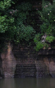
- Washboard Waterfall

Past the bridge I drove in over from Highway 55 I encountered no other boats. At a waterfall that appeared to drip flat on washboard surfaced rock, I saw two small yellow birds that might have been hummingbirds, by the way they moved, but looked the size of small finches. We have some yellow finches hereabouts. I saw a gar swim past me, break the surface, then swim away. The water rapidly becomes shallower there, and stumps, logs, other hazards make it difficult for power boats within about a mile and a half upstream from that bridge. Not much past that, my paddle began scraping bottom. At one point my rudder scraped rocks making a metal-clanging, grating sound.

White wading birds fed on things I could not see along the muddy, gravely water’s edge. They had a body type like Great Blue Herons, but were smaller, and tended to stay in groups of two to six. I saw a flock of black-headed buzzards, as I was coming and going.

Like the Elk River, exploration of the Duck required me to get out of the kayak and tow it behind like a child’s red wagon. Once past the wading, I was able to get back into the boat and paddle a part of the river I’d guess rarely gets any waterborne traffic. I saw large, maybe foot and a half long fish in shallow water beside a partly submerged stump. It hung like an airplane shaped helium balloon hardly moving as I paddled past. I saw dirt tracks used, I’d guess, by locals riding four-wheelers.
Rain fell as I paddled up the channel of the Duck, and as I waded with Campsis Radicans in tow. Even in a downpour, the E68 doesn’t fill up with water, and compared to the last time it rained while I was on the water, today’s shower was a gentle mist. Still, it was pleasant, and the area needs rain.
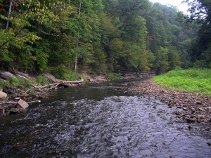
- Looking upstream, Duck River


Looking upstream Cat Creek
I paddled to a fork – what I now believe was Cat Creek lay too shallow for paddling on my right, and the Duck, like a long, low staircase ran swift and shallow over slippery rocks to my left. I waded, towing the boat, up each branch as far as seemed reasonable. Cat Creek first (although at the time, I thought both streams were part of the same with an island between them), then the Duck. I sat on a chair-height rock on the Duck using Campsis Radicans’ foredeck as a table, and ate my lunch. Then packed up and headed back downstream.

Lunch Stop
At Crumpton Creek, I thought about turning left and re-exploring that branch. It has been probably three years since Mike, his son Jesse, and I paddled the strange green, then clear waters there, below Rutledge Falls.
As I neared the boat ramp, I encountered two or three jet-skiis. That just doesn’t look like fun to me. And the expense. You never stop paying for something like a jet-ski. Spoke with a man launching his jet-ski at the boat ramp. He asked how far I’d gone, and I told him. Talked about the rain. About burning gas, burning calories. He said it was about 1:30 pm. The clock in my car said it was more like 2:20 pm. Another long day, and home.

Life in the stream
